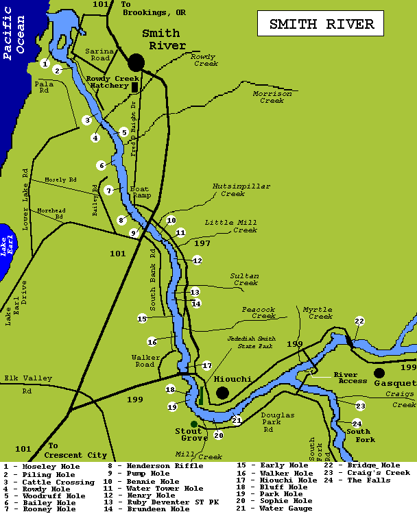
Lower River
The best areas to fish in this section are the riffles and holes between the 101 bridge and Piling Hole. The holes here change from year to year due to the silting and dredging effects of the river. This area is best fished by boat, but wading can also be productive. Pala Road offers the only access to the South side of the river in this section. You can park at the State park and walk about a 1/2 mile to the river. Moseley Hole(1)and Piling Hole(2) can be reached from this area by the levee system.
As always, care should be taken when wading any area.
The next areas to fish in this area are Cattle Crossing(3) and Rowdy Hole(4). Access to these spots is accomplished by taking Sarina Rd, just north of the town of Smith River, to the river. The gravel bar at the mouth of Rowdy Creek is reached from the levee system at the end of this road. This area is brushy and hard to move with a fish on, but is definitely worth the effort.
Further upstream are Woodruff Hole & Riffle(5), Bailey Hole & Riffle(6), and Rooney Hole & Riffle. Access to these areas is accomplished from the boat ramp off Fred D Haight Drive and walking this stretch. Pump Hole(9) is located just down stream from the 101 bridge.
I could find no current information about this hole, so it is up to you to try it and let me know its current status.
Note: Public access to the river from Bailey Rd has been fenced off.
Taking South Bank Road just south of the 101 bridge provides access to the next major holes and riffles.
Within the first upstream mile on this road are access roads to a gravel bar. This bar provides access to Bennie Hole(10) and Water Tower Hole(11). Henry Hole(12) is accessed via North Bank Road, Highway 197. A turnout is located 1.4 miles from 101 and 5.3 miles from the Hiouchi Bridge. From this turnout you can access the downstream end of a large gravel bar.
A little further upstream on 197, is Ruby Van Deventer State Park(13). A large gravel bar is located here with the best area to fish being the long glide available from this bar.
About 1/2 mile south of the State Park is a turnout that provides a short walk to Brundeen Riffle & Hole(14). About another 1/2 mile upstream is a road leading down to the river. The upper area of Brundeen Hole and Early Hole(15) are located along this gravel bar.
Access to Early Hole and Walker Hole(16) can be achieved from Walker Road off Highway 199.
The Southeast side of Hiouchi Bridge allows access to Hiouchi Hole((17). Trail leads to large rock and a gravel bar is located just downstream.
Just west of Hiouchi Bridge on 199 is a gravel road that leads north to a gravel bar. To the south is Hiouchi Trail head that provides walking access to Bluff Hole(18) and Park Hole(19). These holes can also be accessed through Jedediah Smith State Park on the other side of the river.
Traveling upstream on 199, through the town of Hiouchi for about 1/2 mile, turn south on road that crosses Neils Christensen "Slant Bridge". After crossing bridge there is a river access road to your right. There is some good fast water at the bottom of this road. The mouth of Myrtle Creek can also be accessed at this spot.
Further down this road you come to the South Fork of the Smith. Crossing at George Tryon Bridge, you can go left or right. Going right onto Douglas Park Rd leads to Stout Grove. Stout Grove has good parking and toilets. From here a trail leads down to the river where Sophie Hole(20) and Whitehorse Riffle, just upstream from Sophie Hole, are accessible.
The stretch of water between the 101 and 199 bridges, probably produces the largest steelhead caught in California. Just about this whole seven mile stretch is excellent fishing water. Deep holes are found here, where the water hits large rocks or the bank, holding both steelhead and salmon. The riffles below these holes provide good flyfishing areas. Highway 197 runs along the north bank between the two bridges. There is access to the river all along this road, with the main access at Simpson Camp or the county park. There is a road along the south bank that turns off at the south end of the 101 bridge. Upstream on this road is access to the gravel bars along the river. From the gravel bars one can access some good holes and riffles.
These are some of the main holes and accesses along the Smith, as you drive the area you will probably find more. I have attempted to give information that will help you located fish in the river. If you have a fishing experience on the Smith, please E-mail me your story so I can share it with other visitors to this site.
|